We flew into Cordova, Alaska yesterday afternoon, hoping to fly out to tour camp, or “hippie camp” as some of the Points North staff has dubbed it. Instead, we are hunkered down in the rain, watching the otters float by, waiting out the weather. We’ve been meeting new friends, playing foosball and ping pong, and watching movies in the NEFCO Lodge. The waiting game is part of the experience as nature hits the reset button and refills the good lines.
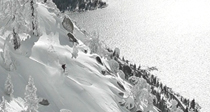
This has been a great ski season so far with plenty of quality powder skiing. Until recently though, I had not really dug into my tick list of bigger objectives in the region. Once the storms abated and conditions stabilized, I began to look toward a tasty zone northwest of Truckee. Local bush pilot Kevin Quinn flew me over the area two years ago and it’s been firmly engrained in my brain ever since. The east to west ridgeline features rolling bowls and gullies, majestic cliffs, gorgeous tree runs and striking couloirs. The remote location that is not easily viewed from anywhere only adds to the intrigue. The time had come to check it out. My ski partner in crime Robb Gaffney was up for the mission. The fact he owns a snowmobile didn’t hurt. Our goal was to work our way into the region and see how it played out. Actually skiing something was of secondary importance. We had no idea what we were in for.
The upper cirque which marks the highest point of the ridgeline.
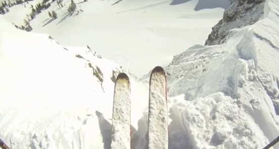
An hour long snowmobile ride ate up the five mile approach and placed us at the north end of a huge basin. Leaving the sled behind for the day, a short tour brought us to the top of the ridgeline and our first glance into the zone I had been thinking about for two years. The first thing we noticed was that north aspects were still holding unconsolidated powder despite recent east winds. We gazed down into steep glades which rolled over into the abyss. We continued along the ridge to the top of a cirque which I had seen from the plane. It was wind scoured and littered with rocks so we traveled a bit further and came to the top of a long, steep, north facing couloir. We skirted around an overhanging cornice and a quick pole scrape told us the snow was good. We knew the low January sun wouldn’t affect the north side so we decided to check out two southeast facing couloirs we had seen on the approach. It was 11am and they were in prime shape for an amazing morning corn descent. Robb dropped into the skiers left couloir and I took a dogleg entrance into the skiers right. We descended between radiant rock buttresses for about a thousand vertical feet of buttery goodness. It was barely noon and the day had already exceeded our expectations.
Our day began with descents of these southeast facing couloirs.
A quick skin brought us back up to the top for lunch and another look into the north facing couloir. Robb entered first and made turns down perfectly edgable steep snow which sluffed hundreds of feet below. I went next and was amazed at how good the conditions were. Massive rock walls and northern exposure had kept this gem in perfect shape despite recent winds. Once at the bottom and full of smiles, we skinned up and started working our way west, constantly looking up the ridge to examine options. The first thing we passed was another large couloir, which started just to the skiers left of the one we skied. The entrance to this one was far more challenging, most likely requiring a rappel or a few very exposed turns. Once in though, it’s about as classic as you could ask for in a backyard discovery.
Robb Gaffney drops into the unknown.
Photo: Robb Gaffney, Skier: Rob McCormick
Skier: Robb Gaffney
The author checks for Sleestaks. Photo: Robb Gaffney
Good to the last drop.
As we continued on, I was blown away by how rowdy the entire region stacked up. If we had dropped into the first sightline we looked into, we would have come upon huge ice bulges, cliffs and other technical challenges. My view from the plane two years earlier had left me with the impression the terrain would be fairly easy to navigate. I now have a new found respect for how complex the entire zone is. We finally came to a frozen lake and a reasonable ascent route. On our way back up, Kevin Quinn and Grant Kaye flew directly over us on their return from ice fishing on Independence Lake. We later discovered Grant had snapped some great photos of the couloir we had just skied (see title photo).
The couloir next door.
The captivating view from Kevin Quinn’s plane in January 2011.
Back at the snowmobile, we sipped a couple of celebratory beers before heading back to civilization. We felt completely stoked to have accessed a thrilling new ski paradise. It seems some of the best days unravel when your only expectation is to explore something new and see where it leads you. We will pay attention to conditions and plan to visit again when everything lines up. Until then, we can only dream about returning to the Land of the Lost.
Next mission…find a way into this one. Photo: Grant Kaye
Thanks to Grant Kaye for aerial photos from 2013. You can check out Grant’s photography website here Grant Kaye Photography
Northern California’s Mt. Lassen is the southernmost volcano in the Cascade Mountain Range. Frequently overshadowed by more prominent volcanoes such as Mt. Ranier and Mt. Shasta, Mt. Lassen is an absolute gem. What it lacks in height (10,463), it makes up for in aesthetic with a beautiful approach, inspiring summit, and a plethora of tasty lines.
The popular south side approach to Mt. Lassen allows skiers to park high on the mountain, hike 2,000 feet up and then ski 4,000 vertical feet down the north side. Although this option is convenient, it lacks in overall experience and feel compared to an approach from the northeast. The best way to ski Lassen is to start from the Devastated Area before the road from the south has opened for the summer. If you are lucky/savvy enough to time your venture when the snow line starts at the parking lot, you can simply put on your skis and point them right at the peak. The result is escalator friendly climb that gradually steepens the closer you get to your goal. Eventually you sling your skis and boot up the last 1,000 or so vert to the top.
The summit of Mt Lassen is classic in many ways, starting with the fact that you can ski from the highest point onto the steepest terrain on on the peak. A well defined summit pyramid gives way to broad, sweeping shoulders that extend to the north and east. Skiers can hit any aspect from east to north allowing them to ski whatever’s ripe for corn. Ambitious types may even consider an alpine start and do multiple laps on the top portion. The total vertical drop from the summit through sweeping moraines back to the Devastated Area is 4,300.
Though it’s one of the little guys in the Cascade Range, Mt. Lassen is a worthwhile ski objective. The northeast face in particular is a great tour and ski from start to finish. It’s also the perfect forerunner for an assault on mighty Mt. Shasta to the north. If you have two or three days you can attempt a one two punch out of these two classic California volcanoes.
Mt. Lassen looms large on the approach.
Grant Kaye on the stairmaster.
Grant Kaye drops in off the summit of Mt. Lassen.
Perfect corn!
Devastated Area parking lot.
Mt. Lassen Blows! This was the scene at Mt. Lassen less than a century ago.
There’s nothing better than a weekend surrounded by friends, except maybe a weekend surrounded by friends in a backcountry palace with a gourmet kitchen, Jacuzzi tubs, sweeping mountain scenery and instant backcountry ski access.
In late April, 25 of us set out into Cold Stream canyon and trekked four miles to spend a weekend at the Lost Trail Lodge. In the winter, the lodge is inaccessible by car and visitors use skis or snowshoes to access it. In the summer, guests can drive most of the way. Visiting near the end of a dry winter, during a 70-degree spell, presented us with an interesting challenge – too wet to drive, and too dry to ski the whole way. We started out towing a sled with skis on our feet and snowshoes our backs. Throughout the trip, we had to remove our skis and walk, dragging the sled over dirt and mud.
Front entrance of Lost Trail Lodge
Lodge owner David Robertson built the majestic lodge from materials that he gathered by hand. On his website, he says that getting there is half the fun. Our crew tends to subscribe to the same notion, but with rapidly-melting snow creating a mixture of snow, dirt and mud, and nine kids in tow, ranging from three months to eight years, getting there and back was maybe 25% of the total fun. The other 75% happened when we kicked off our boots, detached from our sleds and eased into the comfort of our temporary home.
Terrain accessible from Lost Trail Lodge.
The lodge is adorned in “old Tahoe” memorabilia, including a giant buck head, 20-foot river stone hearth, leather couches and bearskin rugs. The hallways are covered with old photos of the area and a host of other interesting and eclectic toys, dolls, games and instruments. The kids played from dawn to nightfall discovering blocks, piano, croquet sets and pint-sized accordion and horns, while the big kids got lost in history through the photos.
Hallways at Lost Trail are filled with stories and nick nacks.
A short trek from the front door offers views of the Pacific Crest Trail, including Anderson Peak and Tinker’s Knob. Though we expected that the warm weather would make for comfortable travel, lounging and sleeping conditions, we were pleasantly surprised at how good the ski conditions were. Cream-cheesy snow lasted until after noon before turning to slush.
Geoff Forcier skiing above Lost Trail Lodge on April 21.
Throughout the days and nights, groups prepared egg breakfasts, chili lunches and pasta dinners in the gourmet kitchen. The kitchen has a six-foot stainless steel Wolf gas stove, a full set of cast iron pots and pans and is stocked with utensils and condiments so we were able to pack light and eat well. Family-style dinners with close friends are something so rare and so special that the warm glow of those warm nights is now a precious memory.
It's not often that you stay at a remote cabin with a cooler kitchen than your own.
Fueled by solar energy, power is guaranteed until midnight so we were able to play music all day and keep the party going well into the night.
After experiencing a magical blend of seclusion, luxury and camaraderie, it was hard to pack up and head home. With much of the snow on the trail having melted during our stay, the return trip took about six hours. Once I recovered from the exhaustion of dragging my pack, skis, snowshoes, cooler and 3-year-old over dirt for three miles, I started planning our next trip – likely during the summer.
The west facing front deck at Lost Trail Lodge is the perfect place to hang out in the afternoon sun.
I recently hooked up with a few friends for a magnificent backcountry ice skate tour in Desolation Wilderness. Hiking and skating conditions were superb. You could not have ordered up better weather. Hanging out under the low January sun in the middle of a frozen lake with granite slabs in every direction and no one else around for miles was nothing short of magical. If this winter is handing us lemons, I think we concocted the sweetest possible lemonade.
Friday the 13th isn't that scary.
Four top and a poodle in Desolation Wilderness.
Looking at the ice is almost as cool as skating on it.
Hang time.
The tour from one lake to the next is as pleasant as the skating.
The pass linking the south side of Mt. Lassen to the north side opened for the first time last Friday evening. A Ranger told us that, because of trail erosion, July 17 is the last day that the mountain is open to skiers.
Our party exiting the northeast side of Mt. Lassen via the devestated area.
South side of Mt. Lassen.
No shortage of snow in Lassen National Park. Unfortunatly skiers are no longer permitted to get after it.
Many Tahoe skiers migrated to the Eastern Sierra last weekend for a stellar corn session. Familiar faces were spotted from Sonora Pass to Tioga Pass and everything in between. Snowpack is standing tall at about two months behind standard melt schedule. It’s going to be interesting to see how many snowfields make it until new snow starts falling next season. Basically if every snow year was like 2011, new glaciers would begin forming in California.
Sunday's objective: the north face of Black Mountain above Virginia Lakes
This would be fun to drive! Vintage snowcat at gateway to Virginia Lakes.
The perfect Eastside vehicle...the Mackvan!
Still plenty of snow in the Eastern Sierra.
Virginia Lakes Resort with Dunderberg Peak in the background.
Post June 12 corn sesh = satisfied!
Need to re-up on calories after the tour? Why not double down on a half pounder from The Barn in Bridgeport?
When the sun finally came out at the end of March I became depressed. I love snowstorms and had become accustomed to skiing powder every day. On March 28 temperatures soared into the 50’s and began radiating twenty feet of fresh snow like a greenhouse. A ski tour that day brought me within striking distance of one of my favorite zones along the Pacific Crest. I frequently observe this region from a distance but was able to get a good look from a nearby peak. I was amazed by what I saw. The technical face was loaded with snow. Lines that are usually questionable at best seemed to go. More importantly, the menacing cornice that overhangs the ridgeline seemed much smaller than usual (i.e. 10 feet instead of 30 feet). A very long approach and frequent storm conditions had kept the region off my radar most of the winter. I took a few photos and skied back to civilization but could not shake what I had seen.
When I got home I started to realize the warming trend was not all bad. Predictable corn cycles do have their advantages. Long approaches become much more feasible. Steeper lines seem more realistic and less intimidating in perfect corn. It was time to refocus my goggles and start getting fired up for ski mountaineering season.
On April 4, Robb Gaffney and I found ourselves standing on top of the ridgeline I had spied a week prior. It was warming quickly and dead calm. A pole scrape of the face below us indicated two to three inches of perfect corn snow. Although we had both skied lines in the region, neither had dropped the direct fall line routes off the summit. We opted to hit the east/southeast face first as it would get rotten soon. Since we gained the summit from the north we did not have a great view of the face we were going to ski. My photos from the week before indicated it would go and looking down it seemed possible so we dropped in. We could not have asked for better steep skiing snow. We leap frogged down the face with one skier advancing and providing beta on what he found. We came across three different crux zones in which the snow had melted out and required some rock skirting. The pitch held steady at 53 degrees for the entire descent. The last couple hundred feet we each selected a different chute and began to link some legit turns together. The bottom of the face even had a little bergshrund to boot. All said and done the line was only about 700 vertical feet, but a solid shot of adrenaline for sure.
The small vertical meant another run was a must in such ideal conditions. We strapped on our crampons and front pointed up a narrow couloir. About halfway up the chute gave way to a gorgeous summit snowfield which became our next objective. Since we climbed our descent route we new what we were getting into this time and were able to really enjoy it. The northeast facing ramp delivered huge before funneling back into the couloir. The chute itself was really narrow and beatup but the overall aesthetics of the entire line were second to none.
Robb booted back up for one more run while I shot video from across the valley. The day had been a tremendous success. Perhaps the most intriguing aspect of the adventure is knowing the zone contains lines that are far more challenging than the routes we chose. Many narrow chutes and straightlines seem possible in perfect conditions. There is also a large steep face that ends in a mandatory seventy foot air. When you consider the fact the nearest road is about five miles away this becomes extremely committing stuff indeed. Plenty of lines for future generations to get after. In the meantime, it was satisfying to tap into a new rush right in our own backyard known as the Pacific Crest.
The first half of this video includes the trip described above. The second half is a recent tour on the southwest shore of Lake Tahoe.
Inspiring and intimidating...a look back at our objective (photo by Robb Gaffney)
Last week a friend and I sessioned one of our favorite zones along the Pacific Crest. Perfect conditions allowed us to ski some exciting new lines. At 600 to 800 vertical feet, it hardly qualified as big mountain skiing. However, sustained pitch and secondary exposure combined with mini couloirs and faces to climb and ski made for an exhilarating day of mini-mountaineering.
Dropping into the center line (photo by Robb Gaffney)
Last Sunday, I met up with a couple of ski buddies for an East Side ski mountaineering adventure. After a successful ski of the Scheelite Couloir on Saturday, they had their sights on the Mendenhall Couloir on Laurel Mountain for Sunday. The Mendenhall Couloir is 4,000 vertical feet with an average pitch of 45 degrees. It has several chokes and twists to keep things interesting. The top of the line is crowned by a large northeast-facing snowfield. This potential loading zone led us to ascend the neighboring, east-facing Pinner Couloir. With a mellower pitch of 35 degrees, and less exposure to snow accumulation at the top, the Pinner seemed a safer climbing route. As the name implies, the Pinner twists narrowly between towering red cliff walls for 3,400 vertical feet. The Pinner was our alternate descent option should the Mendenhall seem too dicey.
Some forecasts called for partly sunny, some for mostly cloudy. Either way, we knew a front was arriving later in the day and we hoped it would hold out long enough for things to soften and make for pleasant skiing. It didn’t. As we began our quest along the north side of Convict Lake, we could see a cloud bank forming above the distant Red Slate Mountain and the dramatic North Couloir. By the time we reached the base of the Pinner, cloud cover had reached the summit of Laurel. I yelled up to my friend Matt, “It’s not going to soften today is it?” “Nope,” he replied. In another 100 yards or so, we came across slide debris that was frozen solid and covered the entire width of the chute. “I’m not a glutton for punishment,” Matt said, “I’m out.” He said not to let his decision spoil our plans and that he was going back to the car to read a book or maybe hit the local hot springs.
I looked up at my other partner Robb who said, “We can still go up this thing and experience it.” Since the Pinner is 35 degrees, I figured I could descend its bowling lane surface with survival turns and slide-slipping if necessary. If it were 45 degrees, I would have promptly turned around. Donning crampons and whippits, we continued up. After a bit we stopped for a snack and water, estimating another 1,500 vertical feet to go.
Farther up conditions changed, and not in a good way. We now had a crust layer that, if weighted properly, post-holed us into dry powder. As Robb began to put distance between us, I found myself front pointing up the couloir on all fours, punching through to my knees every few steps.
A good sweaty while later, I noticed clouds ripping by a few hundred feet above my head. I could see Robb looking down at me from above and could tell he was at the top. The sun began to come out. I finally crested onto a perfectly flat shelf, dumped my gear and walked a few feet to look over the ridge we had summited. I could see neighboring Bloody and Red Slate Mountains and the dramatic landscape that comprises the Eastern Sierra “Range of Light.” The arduous climb began to seem worth it.
After a brief rest, we walked along the tallused ridge to the summit of Laurel Mountain which stands at 11,812 feet. We had great views of Mt. Morrison and Convict Lake and we could look directly into the entrance of the Mendenhall Couloir, our initial objective. We threw a few rocks onto the snowfield and they stuck into soft snow. Having heard reports of recent instabilities on the exact aspect we were looking into we decided to be “gluttons for punishment” and descend the Pinner that we climbed up. It sucked. We actually found soft snow to the skiers right of the chute and had several hundred feet of descent turns off the top. Then we encountered what we knew was coming and skittered and grinded the rest of the way down the long, narrow coully. The snow was slighly more edgable than anticipated. Although it wasn’t pretty, nor was it frightful.
Despite our less than glamorous excursion, the Pinner is actually a magnificent run. In perfect corn, or edgable winter snow, it must be a very rewarding ski descent. It winds through massive red walls for thousands of vertical feet. The only truly unsettling thing about it is the hectic amount of rockfall that zings down from above. As the walls heat up, the cliffs shed rocks that pepper the chute by the hour, if not the minute. We skied past many “chips” of various sizes that were not there on the way up. I highly recommend wearing a helmet of some sort both up and down the Pinner. I also wouldn’t suggest dilly dallying around for any length of time unless you get a thrill out of Russian Roulette.
All said and done the outing was not a total failure. After all, we summited Laurel Mountain, took in some amazing views, got a good workout, and survived the Pinner without injury. The experience should make future Eastside missions seem dreamy in comparison. At the end of the day it reminded me that not all ski tours end with effortless pow turns and shit eating grins. Sometimes it’s just nice to return in one piece.
...must come down.
Details: The Pinner and Mendenhall Couloirs along with many other challenging ski routes can be found in the Convict Creek Region of the Eastern Sierra, just a few miles from the town of Mammoth Lakes.


Recent Comments